|
 Stage 1: Saturday 16 April, Frankfurt - Worms Stage 1: Saturday 16 April, Frankfurt - Worms
ca. 100 km, flattish (400 meters of climbing)
Weather: Cool start (winter trousers!), sunny afternoon
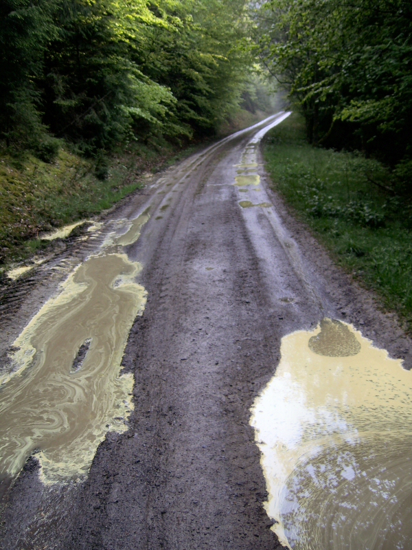
I wait till midday for some sun, but eventually have to set off in warm gear - hmph. Off through the woods towards the Rhine - and sure enough, the sun comes out once I reach the Rhine Velo Route, later prompting a stop for ice-cream. All in all a flattish ride over familiar territory. A nice gentle start to the tour. If you ignore the state of some sections of the Rhine cycleway. (A much overhyped cycleway in my humble opinion.)

Geinsheim |

Cobbles near
Stockstadt |

Rhine Cycleway |
 Stage 2: Sunday 17 April, Worms - Hesseneck Stage 2: Sunday 17 April, Worms - Hesseneck
ca. 110 km, hilly (1400 meters of climbing)
Weather: Gorgeous sunshine
Across flat country to Lorsch with its impressive monastery. I decide to skip an excursion to the Hessian exclave of Ober-Laudenbach - the initial 100 meters of the hill look far too steep and I know the first longish climb awaits me soon anyway. The ride up the Gorxheimer valley. Lots of cyclists out on racing bikes overtaking me up the hill. A few incredulous looks, questions and words of encouragement ("Just how much weight have you got there?" and "Nearly at the top now!"). Then whizz down the Steinach valley to the River Neckar and a well-deserved ice-cream. I take the Neckar cycle track, which is pretty rough in parts, and there's a lovely smell of wild garlic in the air - pity it's not flowering yet (or had it already flowered?). I pass the charming town of Hirschhorn and head to Eberbach. Despite its obvious quaintness I decide not to spend the night there but to enjoy the evening sun and ride up towards Hesseneck, first through some woods and then another long climb up twisting roads, where the only guest house for miles around awaits. All rewarded by a gorgeous view over the valleys and hills as the sun slowly sets.

Lorsch:
The King's Hall |

Cycleway sign:
Talk about multiple personalities |

Hirschhorn |

Hirschhorn |

Borderstone:
Bavaria, Hesse,
Baden-Wuerttemburg |
 Stage 3: Monday 18 April, Hesseneck - Kahl am Main Stage 3: Monday 18 April, Hesseneck - Kahl am Main
ca. 100 km, hilly (1000 meters of climbing)
Weather: Gorgeous sunshine
First on the menu after breakfast is a quick sortie to the "3-Laendereck", where the borders of 3 German states meet - all neatly marked by an ancient borderstone. My first contact with a visible border. The funny thing is: Bavaria had a barbed wire fence ...
I ride along a high road that more or less follows the course of the Limes - a system of defences marking the boundaries of the Roman Empire. Then it's time for the "Radheim Alps" - neatly nestled in one corner of the state. Great views, sweaty hills though, as I head towards the Watchtower of Schaafheim on the border with Bavaria. I reach my destination for the evening early enough to catch a train home, having decided a "rest day" is in order (need to buy more summer riding gear in view of the temperatures and jettison some ballast).

Hesseneck:
Limes - pallisade |

Vielbrunn:
Reconstructed
Roman tower |

Seckmauern:
Odenwald hills |

Lützel-Wieselbach:
Town Hall |

Schaafheim:
Watchtower |
 Stage 4: Wednesday 20 April, Kahl am Main - Mottgers Stage 4: Wednesday 20 April, Kahl am Main - Mottgers
ca. 105 km, hilly (1200 meters of climbing)
Weather: Gorgeous sunshine
After the rest day I take the train back out to Kahl and set off up the valley of the River Kahl - meaning I spend the first 50 km of the day in the Bavarian part of the Spessart. Beautiful countryside, steep hills mind. I sit and eat my lunch at the village pond in Wiesen, before inadvertently taking a wrong turn and whizzing down the hill into Frammersbach! Nothing for it but to ride over another hill and into Hesse again. A nice climb up to Lohrhaupten and then along through the villages of the Jossgrund, the valley of the tiny River Jossa, on roads and cycleways. Temperature well into the 20s - time for ice-cream in Oberndorf before heading up the valley of the River Sinn, where I encounter some rare chequered lilies in the meadows next to the cycle track. They truly are beautiful flowers. Spring really has sprung. I now have to change cycleways and am confronted with the "Hessischer Radfernweg R2". A Radfernweg (long-distance cycle path/trail) in Hesse can often mean some bumpy and convoluted sections, and this one starts very bumpy and pretty convoluted - so I am much relieved when I find an unexpected campsite for the night relatively quickly.

Alzenau |

Wiesen |

Jossgrund |

Zeitlofs |

Altengronau:
Borderstone |
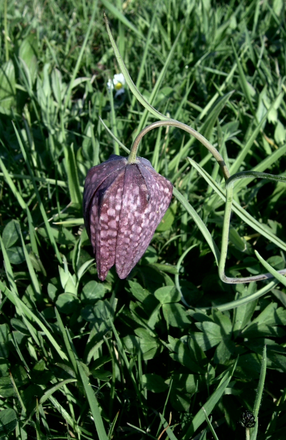
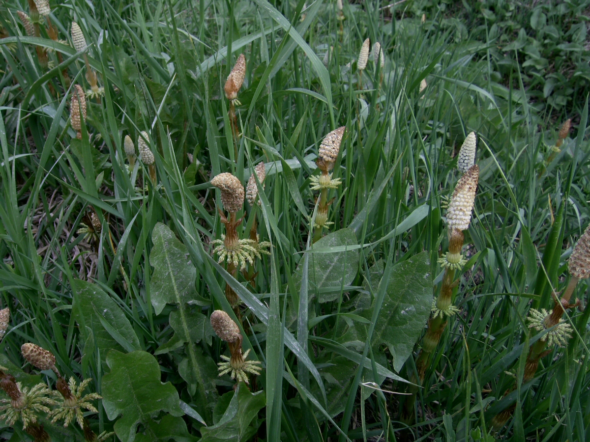
Chequered lily |
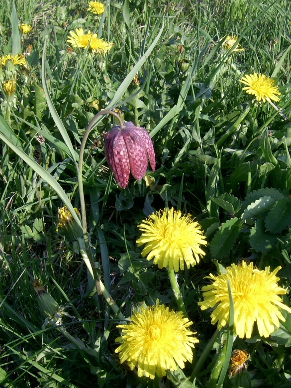
Chequered lily |
 Stage 5: Thursday 21 April, Mottgers - Wüstensachsen Stage 5: Thursday 21 April, Mottgers - Wüstensachsen
ca. 60 km, very steep hills (1400 meters of climbing)
Weather: Blazing sunshine
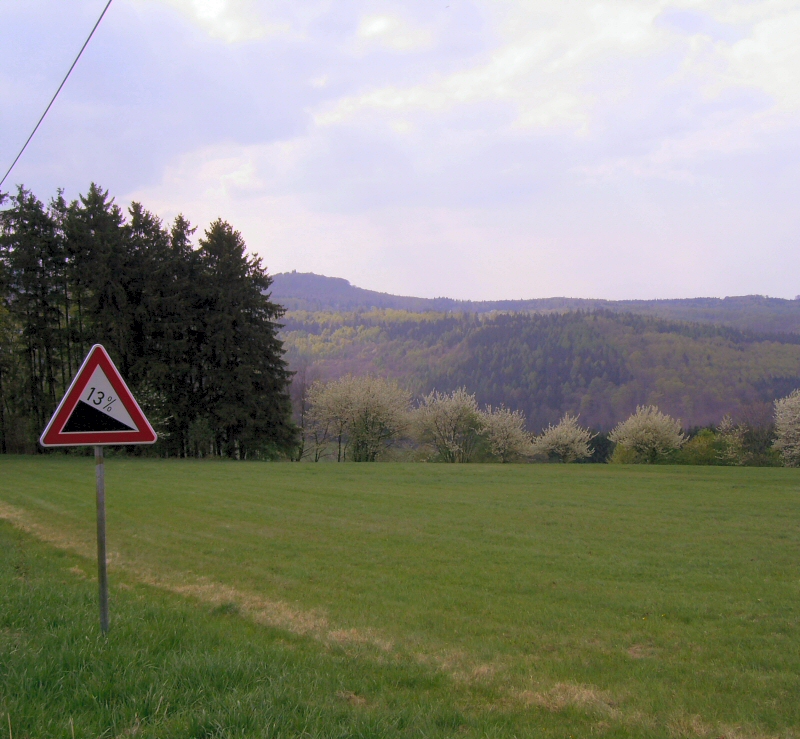
To be honest if there's one word that fills me with joy and fear at the same time it would have to be "Rhoen". The area covered by the Rhön Mountains may not be the Alps, but it is never flat - and especially so once you leave the beaten track - which I do after the first 20 km on roads and cycle paths/farm tracks: I encounter a steep hill with a track made of crushed rock. If the track had been flat I might have been tempted to get off the bike; in view of the 12% gradient I have no choice. The only time I was forced to dismount in the face of overwhelming odds during the entire trip. The chosen route does get better, albeit with an hair-raisingly steep downhill section over gravel and rock that involves almost permanent use of the brakes. At least my route now uses a newly asphalted road (you can tell I'm next to one of the biggest military training areas in Germany - they must need it for access). A joy to ride on. Until Rommers that is. The sign at the top of the village says it all. After a downhill whizz to Gersfeld, it's time for coffee and a break before grinding up to the Schwedenwall (an ancient defensive embankment) on the border of Hesse and Bavaria. Climbing nearly done for the day! As I cross the "Red Moor" (which doesn't look red at all) I decide to add the Wasserkuppe, Hesse's highest mountain, to my itinerary. While I'm up here I might as well give it the full monty. I even rewarded myself with an alc-free beer and some chips! And then on with the wind protection and scream down those hills at 60 kmh all the way to the night's campsite.

Schwedenwall |
After I climbed the
hill through Rommers |
Ferns |
 Stage 6: Good Friday 22 April, Wüstensachsen - Heringen Stage 6: Good Friday 22 April, Wüstensachsen - Heringen
ca. 90 km, flattish (600 meters of climbing)
Weather: More gorgeous sunshine
Having stupidly overlooked the fact that today is Good Friday I have to cancel my planned visit to the "Border Museum" at Point Alpha. So time for a lazy, ambling day after yesterday's antics. And the gentle nature of the Ulster valley is the ideal place for it. Lots of border feeling - this was where the Iron Curtain descended, after all. I also have plenty of time for a proper lunch stop in Vacha in the "East" - a real contrast with the nearby "West". The "house on the border" has a chequered history: 9/10 were in the West, 1/10 in the East, eventualy leading to all kinds of hoo-haaing, before the 1/10 was made inaccessible from the rest of the house! Having pitched my tent in Heringen I cycle along some of the next day's route to take in the beautiful round church in Untersuhl, where I end up playing "tourist guide" for some passing cyclists, who had no idea just what to expect inside. Quite odd really. Me being English and all that.

Wayside shrine |

Wayside shrine (detail) |

Tann: Fountain
with Easter decoration |

Tann: Border
opening |

Vacha: Border
opening |

Vacha: House
on the border |

Vacha |

Vacha: Town hall |

Vacha: The
"Gingerbread House" |

Untersuhl:
The round church |

Untersuhl: The
round church inside |

Untersuhl:
The round church |
 Stage 7: Saturday 23 April, Heringen - Eschwege Stage 7: Saturday 23 April, Heringen - Eschwege
ca. 120 km, flat with hilly evening ride (900 meters of climbing)
Weather: Gorgeous sunshine, but lots of headwind
Once I'd decamped it was off along the Werra cycleway - over the wooden section again, past the round church and into "East Germany" for large parts of the day. Empty roads and cycleways. I did catch sight of a "Trabi" though. The cycleway is rough in parts (very deep gravel) and there is a headwind to boot. The countryside more than compensates for all this however - as does the sunshine. After pitching my tent at a lovely campsite set on a lake, I head up into the hills of "Hessian Switzerland". Alas it will soon be too dark to start exploring the woodland tracks with their supposedly stunning views, so it's back down the hill to the campsite, where I'm greeted by a beautful sunset over the hills of the Hohe Meissner and the sight of Easter Bonfires burning in the villages dotted all over the hills, which seems to be a tradition in this part of the world. Quite a stunning backdrop as I sit on the balcony of the campsite's restaurant and do some serious carbohydrate-loading.

Herleshausen:
Border opening |
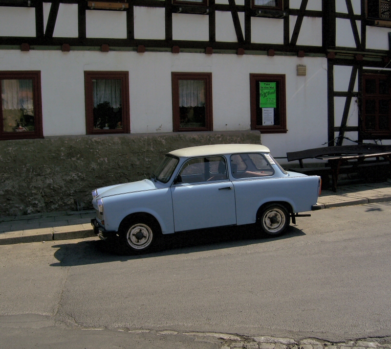
A Trabant |

Eschwege: Sunset
over Meinhardsee |
 Stage 8: Easter Sunday 24 April, Eschwege - Gewissenruh Stage 8: Easter Sunday 24 April, Eschwege - Gewissenruh
ca. 130 km, 1 big hill, lots of little ones (1100 meters of climbing)
Weather: Gorgeous sunshine yet again
The tour continues along the Werra today, stopping first at the stunning town of Bad Sooden-Allendorf with its equally stunning half-timbered houses and buildings. And I even arrive in time for the "glockenspiel" from the bells on the town hall. The Werra is a delightful river valley - I must cycle it all one day! Time now for a big hill as I try and follow the border - via Nieste to Kassel and the River Fulda, which now forms the border with neighbouring Lower Saxony. 20 km later, in Hannoversch Münden, the Fulda and Werra rivers join to create a new river - the Weser. Hann Münden is worth a visit - beautiful buildings - and the Weser cycleway on the eastern side of the river is a dream. And remains so until the midges come out as the evening draws in. Prompting me to seek a room at a guest-house in the old Waldensian village of Gewissenruh perched above the river. Another gorgeous backdrop to dinner: Looking down across the sweeping valley to the villages on the other side of the river.

Allendorf:
Town hall |

Allendorf |

Allendorf:
Border opening |

Lindewerra:
Railway viaduct |

Hann Münden:
Weserstein |

Hann Münden |

Gewissenruh: River Weser
early in the morning |
 Stage 9: Easter Monday 25 April, Gewissenruh - Deisfeld Stage 9: Easter Monday 25 April, Gewissenruh - Deisfeld
ca. 120 km, hilly/dippy (1200 meters of climbing)
Weather: Gorgeous sunshine
First off into Bad Karlshafen - a really charming if somewhat twee town with what we Brits would call a "Georgian" look and feel to it - before heading up the Diemel cyclepath towards the highlands of the Rothaargebirge. The signs along the route leave a bit to be desired. So much so that I take more than one wrong turn today. Could have something to do with the signage policy of the state of North-Rhine Westphalia (NRW). Once I leave Marsberg the road/path starts climbing inexorably up to the Diemelsee reservoir, with one long 10% section. The reservoir itself is a bit of a disappointment, overrun by plebs, and none of the campsites look inviting. A bit frustrated, I decide to ride on - and am somewhat lucky to find a room for the night at a farmhouse. The only accommodation for miles around as I later discover. Luckier still, the farmer's wife lays on some great food for me.

Bad Karlshafen:
The inner port area |

Warburg |

Diemel reservoir |
 Stage 10: Tuesday 26 April, Deisfeld - Diemelsee - Deisfeld - Edersee Stage 10: Tuesday 26 April, Deisfeld - Diemelsee - Deisfeld - Edersee
ca. 80 km, hilly (1150 meters of climbing)
Weather: Overcast, sunny, managed to avoid a shower
Having not taken any real photos of the reservoir yesterday I decide to head back there straight after breakfast without any luggage (picking it up again on the way back). I'm glad I came back here. A complete contrast to the previous evening. No traffic. Everyone still asleep or taking it easy at the campsites. I cycle right round the lake - a real pleasure. The only real noise seems to be the local woodpeckers. After retrieving my luggage, I continue along the Diemel to its source - right on the border with NRW at 660 meters above sea level. In view of the weather forecast (showers, possible thunderstorms), I decide to soften my route and just follow appealing-looking roads/paths until I reach the Edersee, a very large lake/reservoir set in the Kellerwald, and probably best known to Brits as being one of the "Dambuster" dams. Lovely hills here in the Sauerland. The dark and forbidding nature of the area is emphasized by some rain clouds gathering as I head over one final hill. Luckily for me I am able to make myself comfortable at the bottom of the hill (cycling downhill at 50 mph in even light rain is not my idea of fun!) in a large log-cabin type bus shelter before the rain gets really heavy. After half an hour the sun reappears and I soon find a hostelry for the next 2 nights - Pension zum Elsebach (an establishment that would make for a good book by John Irving) - and even fit in an early evening ride along the River Eder before an amazing dinner (fresh asparagus soup; wild boar with a chanterelle sauce, half a pear with cranberry sauce, potatoes, red cabbage with apple; fruit yoghurt for dessert) at the equally amazing price of just 13 euros!

Diemelsee |

Diemelsee |

Diemelsee |
 Stage 11: Wed. 27 April, Edersee - Fritzlar - Edersee Stage 11: Wed. 27 April, Edersee - Fritzlar - Edersee
ca. 120 km, hilly (1100 meters of climbing)
Weather: Overcast, sunny, storm clouds but no rain
A no-luggage day. I ride along the southern bank/slopes of the lake (where I find myself absentmindedly humming the Dambusters tune). It's a big dam - and the hill down to the bottom is, as you might imagine, steep. The Eder cyclepath now follows the eponymous river and wends its way to Fritzlar, a majestic little town full of old, colourful, and often crooked, half-timbered buildings, a whole host of medieval towers, as well as a towering cathedral founded by Bonifatius (Saint Boniface). A medieval paradise really, and I spend a good hour or so soaking it all up. I ride back up to the dam (that hill is steep!) and then along the northern bank before heading down to the peninsula of Scheid. As fortune would have it the ferryman was about to leave but still took me across the lake (thus saving me about 20 but-gusting km over woodland tracks). I wouldn't want to miss dinner at the pension!

River Eder |

Edersee: Looking
across to
Waldeck Castle |

Fritzlar |

Fritzlar |

Fritzlar:
Town hall |

Fritzlar: Bonifatius statue |

Fritzlar |

Fritzlar |

Fritzlar |

Fritzlar: The
Cathedral |

Edersee |
 Stage 12: Thursday 28 April, Edersee - Bad Laasphe Stage 12: Thursday 28 April, Edersee - Bad Laasphe
ca. 100 km, hilly (1100 meters of climbing)
Weather: Sunshine, rain showers (all avoided under shelter)
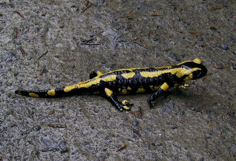
I'm sorry to be leaving this "pension" (German for guest-house with half board). A really intriguing place. Today's plan is to follow the River Eder up to the border with NRW, then cross the hills to the River Lahn. My first stop is at Frankenberg with its famed town hall. And well worth a ride up the steep cobbled hill it is too. Further upriver I pass by Battenberg, which gave its name to a dynasty probably best know to Brits once the English side of the family changed its name to Mountbatten, before seeking refuge in the nick of time from a pending shower. The cycleway is rounded off by 10 km of fresh asphalt that ends abruptly right on the border with the next state. After refeshments in the sun at a cafe, more rain clouds appear, but once again I get to a bus shelter in the nick of time. It's my lucky day - because it slews it down for 15 minutes. Now to find the "R8" - my cyclepath over the hills. Being a major route you'd expect there to be lots of signs. There are none at all. I find the route on my map, and it starts with a very steep road, then come woods and lots of tracks, all diverging uphill in different directions. I just follow my nose and my compass and head up and south. God knows where I was. I suspect somewhere very close to the biggest hill here, the Sackpfeife (which literally translates as "scrotum whistle"). I certainly never found the R8. I did find a fire salamander though. Nearly ran over the poor devil (who was probably only active in daylight because of the very recent rain), with only a quick bunny-hop on my part (a foolish manoeuvre with hindsight, as I was going downhill quite fast) saving his skin. I also managed to find the other side of the hill and come out close to my intended main road, subsequently heading for the town of Biedenkopf for the night. I find the town oppressive and ugly and so ride up the Lahn and over the border into Bad Laasphe. Which turns out to be a very nice old town with an appealing half-timbered inn that is also a private brewery. Which rather sorted out my accommodation problem for the night!
 Stage 13: Friday 29 April, Bad Laasphe - Probbach Stage 13: Friday 29 April, Bad Laasphe - Probbach
ca. 90 km, very hilly (1300 meters of climbing)
Weather: Sunny, overcast in late afternoon and evening
The Westerwald - another hilly border region. Hillier than I had imagined. It starts off gently enough by the River Lahn but soon turns more strenuous once I veer away from the river and head up the main road through a former mining region to the Bettelbuche and the source of the River Dill. Down the hill through the forest is nice - the track is asphalted! Unfortunately I am going so fast I miss the source of the Dill, soon arriving in the town of Haiger, which I find not to be to my taste at all. A brief coffee stop and then the climbing starts again. The main road is busy and once I reach the top I am pleased to meet a lady mountain biker who guides me away from the traffic and over to the Fuchskaute and the 3-Laendereck, where the states of Hesse, NRW and Rhinland-Palatinate meet. Using roads again I ride down to a reservoir where I had intended to camp, but the weather looks inclement, to say the least, prompting another hour up and down the hills (nice asphalt allowing for really fast descents :-)) till I find - perchance - a reasonably-priced country hotel for the night.

Bettelbuche |

Borderstone:
Hesse, NRW,
Rheinland-Palatinate |

Elsoff |
 Stage 14: Saturday 30 April, Probbach - Lorch Stage 14: Saturday 30 April, Probbach - Lorch
ca. 130 km, very hilly (1350 meters of climbing)
Weather: Sunny
Penultimate day and still not sure what route to take. Breakfast brings a decision: Along the Kerkerbachtal cyclepath (a former railway line) to Runkel on the River Lahn first of all. This starts off benignly enough but soon develops into a mountain bike trail; given a choice I am unlikely to ever want to cycle along this route again. Never ever. The track has mostly been "surfaced" with crushed rock and gravel. At least the torture is over after 25 km and I arrive in Runkel, a nice little town dominated by its imposing castle. My route now follows the River Lahn - an excellent cyclepath - past Limburg to Diez where I then take the Aartal cyclepath, which seems to follow an old railway line and which runs close to the border into the neighbouring state of Rhineland-Palatinate. I reach a point where I know I have to climb a hill or two to ensure I stay close to the border and can reach my planned destination for the day - Lorch on the River Rhine. And what a hill or two they turn out to be. Still, the higher I get, the better the views over the hills. And once at the highest point, I get to ride down the valley of the tiny River Wisper, the Wispertal, perhaps one of the most beautiful valleys in the whole of the Taunus Mountains. Lorch is a very quiet place - if you discount all the goods trains rattling along the Rhine. I'm glad my hotel is a long way from the railway lines!

Waldernbach |

Kerkerbach valley:
Old mine entrance |

Runkel |

Limburg
Cathedral |
 Stage 15: Sunday 1 May, Lorch - Frankfurt Stage 15: Sunday 1 May, Lorch - Frankfurt
ca. 100 km, hilly at first (700 meters of climbing)
Weather: Gorgeous sunshine but headwind
Last day and only 50 km of border, then 40-50 km along the River Main to home. The cycle route on the northern side of the Rhine follows the main road initially, so in Rüdesheim I decide to take the "Riesling" route through the vineyards and up to the monastery at Eberbach (where much of the film "The Name Of The Rose" was shot). Some nice views of the Rhine at first, but the route is quite unspectacular, just hilly and windy. After coffee at the monastery (overrun with tourists on this pleasant Sunday) I realize that I now have to head down to Mainz. Again the route is unspectactular (and in parts downright ugly). I can tell I'm approaching the Rhine-Main area. Lots of traffic, lots of people. A bit of a shock after two weeks in sparsely populated areas. The final 40 km or so along the Main cycleway battling the headwind are compensated for by arriving in Frankfurt in time to catch the end of a professional cycle race in the city centre: Real cyclists on real racing bikes going real fast.

Sooneck Castle |

The Rhine |
|
| Postscript:
So how close did I stay to the border? Looking at the map, I would have to say "very close".
Was it a "worthwhile" tour/idea? Oh yes. Some beautiful countryside. Some lovely cyclepaths. This tour has actually prompted me to start a library of pictures showing the paths/tracks I love to ride along/on/over, and in some cases around or even avoid. Click here to see more.
What impressed me most? The flora and little bits of architecture. Hillside meadows covered in dandelions. I must have been impressed - it's not like me to take so many photographs when on tour. Above all though it was the peace and quiet, only "interrupted" by the sounds of bird-song and bubbling rivers and streams. The birds themselves were also impressive, with lots of bussards, red and black kites, storks and herons. Seeing a fire salamander was a real stroke of luck as they are normally only active at night. Talking of night: Being away from the city, it was a real pleasure to see the stars at night.
Which "border" towns would I recommend for a visit? In no particular order of merit: Eschwege, Hann Münden, Bad Karlshafen, Hirschhorn, Vacha, Fritzlar (which is admittedly a long way from the border), Bad Laasphe, Runkel, and Limburg.
Which "border" cycleways would I recommend for a tour? If you like it "flat", the Werra and Weser cycleways. If you like it "hilly", any and all you can find in the Odenwald, Spessart and Rhoen regions.
What surprised me most? That fire salamander. I tell you, he is one lucky animal. He was only inches away from becoming road-kill.
What disappointed me most? True to Goethe's motto "There are no disappointments in life, only the wrong expectations!", very little indeed. Perhaps the fact that the wild garlic was not in flower. And I couldn't find any trace of the (supposedly) thousands of cherry trees in Witzenhausen.
Would I do it again? If you pay me, I will. But this time in a clockwise direction.
|
|